Tuesday, 15 May 2012

Loyalist Burial Ground

Walking along Brunswick Street in Fredericton you'll come across this large stone at the intersection of Carlton Street. This is a Monument to the United Empire Loyalists, a group of people, still loyal to the Queen, left the United States after the Revolution and came to New Brunswick.  

Incase you have never stopped to take a look, it says the following.
TO THE MEMORY OF THE 
UNITED EMPIRE LOYALISTS
WHO SETTLED IN THIS REGION
FOLLOWING THE AMERICAN REVOLUTION
***
COMPELLED TO LEAVE THEIR HOMES IN
THE THIRTEEN COLONIES FOR THEIR
LOYALTY TO THE CROWN THEY FOUNDED
THE PROVINCE OF NEW BRUNSWICK
IN 1784 TO SECURE BRITISH INSTITUTIONS
FOR THEMSELVES AND THEIR POSTERITY
***
MANY OF THESE LOYALISTS LIE BURIED HERE
***
SPEM REDUXIT
***
ERECTED 1783 BY THE FREDERICTON BRANCH
UNITED EMPIRE LOYALISTS ASSOCIATION OF
CANADA ON THE 200TH ANNIVERSARY OF THE
ARRIVAL OF THE LOYALISTS IN THIS PROVINCE


Spem Reduxit is also featured on the New Brunswick coat of arms, and means "Hope was restored".

Walking through the graveyard will join you back up with Carlton Street. There are plenty of trails which lead you deeper into the graveyard, some of which are surprisingly quiet and peaceful as they are not often used. 


On the Brunswick Street side is a new addition to the area; a map which lists the names and locations of the various graves and people. If you are "New Brunswick Royalty" (of Loyalist descent), and you are in the area, stop by to take a look and see if any of your relatives are listed!

Tuesday, 8 May 2012

Priceville/McNamee Footbridge

The drive from Fredericton to Miramichi (Route 8) is one of my favourite because of the varied scenery, beautiful views, and the occasional town. There are plenty of little places to stop for a break, such as the Village Family Restaurant in Doaktown. Another stop I would highly recommend is the Priceville Footbridge.


Stretching 200 meters across the Southwest Miramichi River is a suspension bridge that connects Priceville to MacNamee. Originally built in the 1930's it collapsed in 1939, killing 3 men. 


A new bridge was built, and then replaced in 1988 with the current iteration. 


This isn't for the faint of heart, but does offer some spectacular views of the Southwest Miramichi. 


Once you have made it to the other side you have arrived in Priceville! If you are into Geocaching you might even find a cache or two in the area.

You can find the Priceville footbridge east of Boiestown by turning off Route 8 onto the McNamee or Carrolls Crossing Road. 


Friday, 4 May 2012

Reardon Road Overpass

Although incredibly useful, the Fredericton to Moncton highway (Route 2) can be a bid tedious at times. A lot of the trip is spent driving through woods, with the only real pit stop being the Youngs Cove Irving.

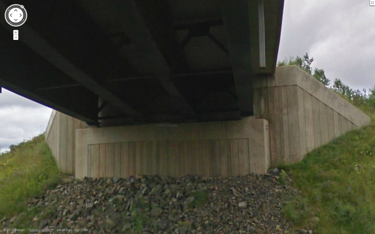
Other than trees, I'd bet the next most abundant element is the over passes. The Reardon Road, which connects Route 105 and Route 695 is one of these concrete structures, but has a twist. 


Every other overpass (as far as I can tell) has the typical 'plywood concrete form' look. The Reardon Road (both east and west lanes) has a board and batten type design, with an interesting retaining wall as well. Why is this one different? The road isn't anything special; in fact having an overpass there probably wasn't necessary, considering there are two major on/off ramps minutes down the road.


Regardless, it is nice to see a touch of personality put into something as utilitarian as an overpass. You can find this oddity between the Coles Island and Mill Cove exits, so keep your eyes open.

Tuesday, 11 October 2011

Fredericton to Moncton Highway Article

For those of us who were not old enough to remember the construction of the Fredericton to Moncton highway (aka myself), this is a very interesting article discussing the construction.

http://www.cbc.ca/news/canada/new-brunswick/story/2011/10/07/nb-f-fredericton-moncton-highway-231.html

It brings up the issue of forgotten communities although does not delve too deep as the main purpose of the article is to allude to the $10 billion debt NB has accumulated. Here is a portion of the article specifically talking about the effect the new highway had on communities.

Future of communities

It was feared that the highway, which was intended to keep drivers along one of the province’s most heavily-used corridors safe, would also push some communities to the brink of financial ruin.
Communities and many small businesses that had cropped up along the side of the Trans-Canada Highway over the decades and profited off the non-stop stream of traffic from transport trucks, tourists and commuters.
Sussex was one of the communities that feared the worst when the highway debate was raging in the 1990s.
Emily Palmer, a former mayor of Sussex, said in a 1996 interview that the number of visitors in places like Sussex, Coles Island, Youngs Cove and Cambridge Narrows would be slashed.
Palmer said in a recent interview that her predictions have become reality and that minimal traffic is making it off the highway and into these smaller communities.
“Everything is bypassing us,” Palmer said.
“So we’ve seen a lot of small businesses that have closed, a few have opened but a number of them haven’t stayed.”
Sussex is now 35 kilometres south of the highway.
Several businesses and towns chipped in to build a tourist centre just off the highway in 2003. The idea is to direct tourists who make a quick trip off the highway to take a longer detour to some of the communities and attractions that are along the old highway.

The tourism centre mentioned in the article is a mock covered bridge at exit 365 (Sussex, Youngs Cove, Chipman). Although I have often driven by it, both on the highway and the road to Sussex, I have never stopped. I find it often appears to be closed, but it might be worth a second look.

Thursday, 6 October 2011

Waterborough


If you’ve driven the Fredericton to Moncton portion of the Trans Canada Highway, you’d agree that it’s possibly the most boring section of highway in New Brunswick. Luckily, if you have spare time, a third of the drive can be spent within view of the Saint John River. This is route 105, which leaves the northside of Fredericton and continues east until Youngs Cove and eventually back on the Trans Canada.
Waterborough can be found on the east side of Grand Lake along Route 105. It’s not a place you would notice other than the typical DOT approved sign, but certainly deserves a closer look. As mentioned, Waterborough overlooks the beautiful Grand Lake, which is the largest freshwater lake in the province.


I only had the opportunity to stop at the Waterborough Community Wharf, but it was a nice chance to stop and enjoy the scenery. 


Saturday, 13 August 2011

Hello World

Hello everyone, my name is Lee and  I live and work in New Brunswick, Canada. This isn't my first foray into blogging, but will be a major step. As an engineer, my writing skills aren't my strong suit, so bear with me!

I travel a fair amount for work, and this bodes well for my love of New Brunswick. I’m always trying to keep an eye out for that forgotten nook or overlooked detail. What I find interesting is when travel patterns change, causing a once busy spot to become 'off the beaten path'. I’ll also look for architectural details, statues, signs… any small piece of history lost in the hustle and bustle of our daily lives.

I think these are the spots that define New Brunswick. For better or worse, they have become parts of our everyday lives and melt into the background. These are the spots that visitors and locals alike should know about. With this blog I hope to bring these to the forefront for people to enjoy. Hopefully in the process they will learn to love these areas as well.

I am always open to suggestions, just drop me a line!

Lee